 Live Music Archive
 Librivox Free Audio
 Metropolitan Museum
 Cleveland Museum of Art
 Internet Arcade
 Console Living Room
 Books to Borrow
 Open Library
 TV News
 Understanding 9/11
tv CNN Newsroom CNN October 29, 2012 8:00am-9:00am PDT
8:00 am

ws. hello, everyone. i'm ashleigh banfield. it is 11:00 on the east coast of the united states, it is 8:00 on the west coast. welcome to our viewers from around the world. it could be bad. that's what the coast guard is saying. an admiral with an eye on hurricane sandy. or it could be devastation. not great choices. just hours before the center of this vast and powerful storm meets up with a cold front on the eastern seaboard, it is threatening and/or disrupting some 60 million people, from north carolina all the way up the coast to maine. wind damage, storm surges, inland flooding, snowstorms, all of these in the forecast, along
8:01 am
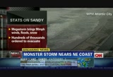
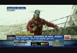
with inevitable power outages that could last for days, if not more than a week. that's why hundreds of thousands of people who live, work or play near the water, including the spot you're looking at right now, atlantic city, they're all under a mandatory evacuation order. it's why classes are canceled for more than 2 million schoolchildren. it's why more than 10 million commuters in new york, philadelphia and washington have no bus service, have no subway service today. and thousands of airline flights, almost 10,000, in fact, into and out of the northeast corridor are canceled. if you need to drive anywhere in connecticut today, you better hurry up because the governor of connecticut has just announced he's shutting down the highways at 1:00 eastern. and that is just two hours from now. here where i am in new york and where we begin our mega coverage, my colleague, john
8:02 am
berman is down in battery park city, which pretty well can be expected to get battered as the namesake is. sandy is turning towards the shore and picking up speed. give me a bit of a read from your location. >> reporter: it's really been an interesting place to be all morning. about two hours ago, i was standing in 8 inches of water right here. it was up past my ankles. what happened was after high tide here in morning, there was a small storm surge. the water came up over this seawall right here and began to flood this area. this is the evacuation zone in lower manhattan, some 370,000 people have been told to get out from here and also the other boroughs in new york city to evacuate, get to a friend's place uptown, get to a hotel or to one of the 76 emergency evacuation centers throughout the city. they're expecting a storm surge of anywhere between six and 11 feet. that's a lot. we saw at high tide this morning it come over the wall here, that
8:03 am

was a mere fraction of what it will be tonight at about 8:50. that's high tide tonight. with this full moon and with this storm hitting the east coast, the water could come in and simply flood this whole area. what you're seeing here is a lot of tourists, a lot of people coming to take pictures. this is a bad idea. i don't think these people knew just an hour and a half ago, they would have been standing in 8 inches of water or if they come here tonight, they would be floating or sinking. the police have come through here and told people to get out of here. this is really a bad place to be. this is a mandatory evacuation zone in lower manhattan. 6 to 11 feet of storm surge. it's not big waves like you've seen up and down the east coast. there are some pretty amazing pictures up and down the east coast. no, this is a slow creep. the water will simply rise behind me. hour by hour by hour as we get closer to 8:50 tonight. and then it could simply be devastating. ashleigh? >> this is even more sort of secret and stealthy for those
8:04 am

who don't know what they're about to walk through. new yorkers, all 400,000 of people who have been ordered to evacuate are a hearty lot and don't heed the warning. what do we know about where you are, where the mayor's threatened to shut off the power down there? have they left and gone anywhere? >> reporter: most of the people i've seen here are tourists. they aren't native new yorkers. they're people who may be in hotels nearby and they just came to get a look here. you can see the police are walking down here right now and telling people to get out of here. it's not a good place to be. i'm telling people that i see here, they should get in, hunker down, it really only started to happen about half an hour ago where people started to come out. earlier this morning, it was a ghost town. that's what new york should feel like today. it is a very good day to be at home. >> i'm glad to see what i'm seeing behind you, the police officers responding and telling people this might look like there isn't a problem but there is. stay with us, john, if you would. i want to move on that jennifer
8:05 am

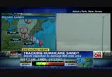
delgado because i'll tell you something, there's a lot going on that people might not be able to see. the new advisories have been rolling in. we just got one from the national hurricane center. hurricane sandy is about 205 miles southeast of atlantic city. and our meteorologist, jen delgado, is joining me live from the hurricane center, tracking this storm. there's some significant news that's just come out. tell me about it. >> absolutely. most importantly, we are going to start off with the winds. the winds have gotten stronger from the last advisory at 8:00 a.m. we are now seeing the winds sustained at 90 miles per hour with some gusts up to 115. so, yes, we are still seeing strengthening out of it. and we're talking hurricane sandy has been moving right along the gulf stream. we think that was allowing hurricane sandy to strengthen over the last couple of hours. want to point out to you also the pressure. the pressure has also dropped. we're now looking at it being 943 millibars. that's the lowest pressure
8:06 am
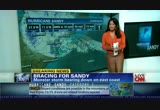
recorded for a storm north of cape hatteras, north carolina. we are not done by any means with hurricane sandy. we still have to go through late tonight as well as into tomorrow morning before we see that circulation making landfall. again, you can kind of see for yourself right now, it's located roughly about -- looks like 268 miles south-southeast of new york city. and it's now made that northwesterly turn. as it makes landfall, it's going to bring hurricane conditions across the region. talking those winds are going to be extremely gusty. they will be moving very slowly. as it does up towards the north -- this is going to be producing a tremendous amount of rainfall. and the rain is already coming down. you can see for washington, d.c. as well as for baltimore, the storms in yellow and orange, of course that indicates the heavy-year rain. out towards the west, snow.
8:07 am

ashleigh? >> just quickly, i've got a lot of ground to cover, but when we came into this today, we thought we'd be looking at winds around 75 miles an hour. and then to hear now maximum sustained winds, 90 miles an hour, gusting to 115 miles an hour and the wind speed, the fact that it's a cat 1, that makes this thing so damaging and powerful. can you explain to our viewers why it's far more serious than that? >>. >> absolutely. it's going to be interacting with a low that's coming through. this is going to turn into essentially a perfect storm. it's going to shift over and getting its energy from a baraclinic motion. the storm is going to continue to blow up on radar. talking very heavy rainfalls intensified out of this. and of course snow. some of these locations, talking about blizzard on the backside of that low. that's going to be developing in parts of west virginia.
8:08 am

you asked with the intensification, as we said, moving along the gulf stream, very warm waters. the gulf stream moves along the eastern coastline and has been moving over there. and that's what really, we think, been the fuel. we've seen that intensification of the storm developing and the center of circulation. don't focus on the center. the strongest winds are all around the storm. >> i keep hearing post-hurricane winter cyclone. i don't like the sounds of that at all. jen delgado, thank you so much. we have more to update you on right after this. ♪ ♪ ♪ we're lucky, it's not every day you find a companion
8:09 am

as loyal as a subaru. love. it's what makes a subaru, a subaru. if you're a man with low testosterone, you should know that axiron is here. the only underarm treatment for low t. that's right, the one you apply to the underarm. axiron is not for use in women or anyone younger than 18. axiron can transfer to others through direct contact. women, especially those who are or who may become pregnant, and children should avoid contact where axiron is applied as unexpected signs of puberty in children or changes
8:10 am

in body hair or increased acne in women may occur. report these signs and symptoms to your doctor if they occur. tell your doctor about all medical conditions and medications. do not use if you have prostate or breast cancer. serious side effects could include increased risk of prostate cancer; worsening prostate symptoms; decreased sperm count; ankle, feet, or body swelling; enlarged or painful breasts; problems breathing while sleeping; and blood clots in the legs. common side effects include skin redness or irritation where applied, increased red blood cell count, headache, diarrhea, vomiting, and increase in psa. see your doctor, and for a 30-day free trial, go to axiron.com.
8:11 am

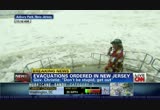
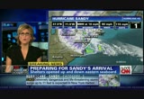
at meineke i have options... like oil changes starting at $19.95. my money. my choice. my meineke. don't be stupid, get out. go to higher, safer ground. the margin for error for me being wrong and you going to stay at a friend's house for two days i think is significantly better than winding up with a severe injury or death for yourself or for your family. >> that's new jersey governor chris christie. he's not messing around with his message. his state is right in the path of this storm. newark's liberty airport is basically shut down. hundreds of flights have been canceled because of this storm. our rob marciano is keeping an
8:12 am

eye on things in asbury park, new jersey. rob, last year just before hurricane irene, chris christie told people in no uncertain terms and i will quote him here, get the hell outfit beach. my question to you, are people heeding his message to get out and get to safer ground? >> reporter: you know, they are. and you may remember, he caught some criticism for using those strong words last year after what people along the immediate jersey shore felt was an overreaction. certainly after irene's disaster, turned out to be a wise choice, especially for those living along the immediately shoreline. here in asbury park and up and down the northern coastline of new jersey, they have certainly heeded his warning. here's a look at the surf that continues to pour in. the tide is actually receding now. but i've only seen it go down maybe five, ten feet in the last 20 minutes because the actual surge continues to push water
8:13 am
over what should be dry, sandy beach here. but obviously that's not the case. so i think throughout the afternoon, even though the tide is going down, we're going to see it hold where it is. and when high tide comes again later on tonight around 8:00, right when this is supposed to make landfall, about 50 to 80 miles to our south, that's when we expect the water to come up and over the boardwalk. tell you what, this surf coming in here has been impressive. all day long, we've seen 10, 15, even some 20-foot huge breakers really testing some of the jetties and seawalls here that protect this stretch of coastline. yeah, everyone's evacuated. mandatory evacuations up and down the coastline to all of new jersey. there are shelters set up. there's been a few hundred people that have taken advantage of those. officials here at the fire department here tell me there have been a few calls they've had to deal with. but all in all, so far, so good. the storm itself is still a couple of hundred miles away.
8:14 am
we have all afternoon long and all night, residual wind pounding the coastline to deal with. in for the long haul here. >> looks so aggressive that, surf behind you. we're just at the beginning stages of it. rob mars nocianomarciano, stay . we're not only going to watch what rob's been watching, the surf, surge and the flood danger. but coming up, what's going to happen when millions of people are almost certain to lose power and how long is it going to take for people to get up in the buckets and fix those power lines and make sure that it is safe just to go outside? that's coming up next. [ woman ] it's 32 minutes to go time,
8:15 am

and the candidate's speech is in pieces all over the district. the writer's desktop and the coordinator's phone are working on a joke with local color. the secure cloud just received a revised intro from the strategist's tablet. and while i make my way into the venue, the candidate will be rehearsing off of his phone. [ candidate ] and thanks to every young face i see out there. [ woman ] his phone is one of his biggest supporters. [ female announcer ] with cisco at the center... working together has never worked so well.

8:17 am

seems like a pretty vulnerable area because we're so close to the water. >> preparation, whatever we can do to minimize any damage to homes and the city in general. >> i have two little kids and a dog. i figured if the power went out, we don't have any generator. so going up 15 flights of stairs would be a pretty big task. >> smart people getting a move on things early. as many as 60 million people
8:18 am
could be personally affected by hurricane sandy. the storm could leave whole cities powerless for as long as a week. maybe even longer because some of these sustained winds that are going to stick around for a while mean that those power companies can't get their guys up in their equipment to fix the lines. it could be very dangerous to be out on the street and it could be very bad for getting power restored. we saw the impact of this when major storms tore through the northeast earlier on this year. but the red cross says it is ready for this storm. and joining me now on the phone is katherine barday, a spokeswoman for the red cross. she's in atlantic city, new jersey. katherine, we just saw in an area that -- where rob marciano was, the storm surge is coming up. even when the tide is receding, the water is still coming up. that should be a clear indication for someone who's out there and wondering when they need to leave, right? >> absolutely.
8:19 am

if water is rising in your neighborhood, we absolutely courage people to evacuate. red cross has shelters open all up and down the eastern seaboard. we've had over 190 shelters open with over 4,500 people staying just last night alone. we have hundreds of disaster workers and we're ready with supplies and emergency vehicles in place to help. and to find a shelter, we have very easy ways to do so. you can download our hurricane application from redcross.org. visit our website, or call 1-800-red-cross for this information. >> that's great information. just quickly, i want to ask you, if someone's watching this and saying, i see standing water in my neighborhood. it's very dangerous to drive on just an inch or two of water. let's say they're about to leave. what should they grab before
8:20 am

they head out the door to get to a shelter? >> well, first and foremost, we want everybody to use extraordinary caution going through their neighborhoods and standing water. but when they leave, we courage everyone to take their medications, personal documents. if they have special needs or need lifesaving medical devices, please take those. battery chargers. and if you have pets, please bring pet supplies with your pets, collars, leash. and make sure that you are headed to a pet-friendly shelter. we have many of those open. and we also partner with other agencies to make sure that pets can be accommodated. please do not leave your pet behind. >> and make sure they grab their insurance policies, along with those important documents. i just want to jump ahead really quickly to after the storm. i know that you're busy now but
8:21 am

you're going to be busy then as well. what he is the plan for after the storm when the damage is done and people are really going to need the help? >> well, red cross will be here for weeks to come. this is a large-scale disaster response. and really we rely on the generosity of volunteers and the public to be able to support such service, whether it's shelters, mass feeding, all of the services that we are going to be providing. and we encourage -- if you would like to find out how to volunteer or make a donation to red cross, please visit redcross org or text the word "red cross" to 90999 to make a $10 donation to this disaster relief effort. >> catherine barde, thank you so much. stay safe yourself as you continue to watch out for the safety of others.
8:22 am

again, for more information from the red cross, 1-800-red-cross. check them out also at redcross.org. a whole bunch of apps on your ipad that will help you to find shelters and get information and find the go bags and what to pack in your go bag. i want to just direct your attention to live pictures right now. the international space station just happens to be, as we speak, flying over hurricane sandy. so the picture that is you're seeing are the actual live shots of what this storm looks like from space. it's remarkable that we just had this timing. but we seized on the opportunity to jump onto their live cameras from the international space station. thank you to nasa tv for this as well because you can just see that wall of clouds. it's hard to get perspective when you're looking at the globe from that angle. but you can certainly see what everyone's been talking about. and that this is a monster storm. we've got a lot more very
8:23 am

valuable information for you coming up. ♪... ♪... choose the perfect hotel starts with arthritis pain and a choice. take tylenol or take aleve, the #1 recommended pain reliever by orthopedic doctors. just two aleve can keep pain away all day. back to the news.
8:24 am

just two aleve can keep pain away all day. anncr: every president inherits few have faced so many. four years later... our enemies have been brought to justice. our heroes are coming home. assembly lines are humming again. there are still challenges to meet. children to educate. a middle class to rebuild. but the last thing we should do is turn back now. president obama: i'm barack obama and... i approve this message.
8:25 am

[ "the odd couple" theme playing ] humans. even when we cross our "t"s and dot our "i"s, we still run into problems -- mainly other humans. at liberty mutual insurance, we understand. that's why our auto policies come with accident forgiveness if you qualify, where your rates won't go up due to your first accident, and new car replacement, where if you total your new car, we give you the money for a new one. call... to talk to an insurance expert about everything else that comes standard with our base auto policy. [ tires squeal ] and if you get into an accident and use one of our certified repair shops, your repairs are guaranteed for life. call... to switch, and you could save hundreds. liberty mutual insurance -- responsibility. what's your policy?
8:26 am

i'm very concerned when i see the map and i see it, i'm very nervous. but i think i'm in good hands here. i think i'm safe. >> hurricane sandy has a lot of people nervous. she's not the only one. this thing's making its way towards the east coast. and it is not stopping. the storm has also severely impacted travel. more than 10 million commuters who take mass transit in new york city and washington, d.c. and philadelphia, they are all without service today. thousands of flights also canceled. and amtrak has canceled its service along the eastern seaboard as this massive weather system or series of systems approach. our meteorologist jennifer delgado is watching things in the cnn hurricane tracking center. she's looking at the storm. we heard from you about 20 minutes ago that we had this big update on the maximum sustained
8:27 am

winds, moving up to 90 miles an hour. gusting up to 115. that's still a cat 1. >> a strong cat 1. >> 6 miles per hour away from it becoming a cat 2. is that possible? >> we just don't know right now. we know that we saw brief intensification out of this from the last advisory where it was 85. now the winds, as we just heard, are at 90 miles per hour. now, the gusts, 115. keep in mind the diameter of the center of circulation, the eye. we're seeing it now roughly diameter of 23 miles. also new here, the pressure has dropped down to 943 millibars. this is the lowest pressure recorded for a storm north of cape hatteras, north carolina, in quite a while. again, this is really an interesting feature. and we really believe this intensification -- because it was moving over the gulf stream.
8:28 am
you can see for yourself. weather conditions are going to deteriorate. this is going to make landfall late tonight into early tomorrow morning. keep in mind, you see how it moves over towards the west. we're going to see hurricane force winds in a very wide area because the storm is so big. now, pointing out to you some of the travel delays and the ripple effect. look at atlanta as well as into charlotte. we are dealing with delays and volume because of the cancellations. that's only going to get worse. today is just not a good day to be flying. as we take you back over to our tracker explorer, look at this. the flight explorer, this is the northeast. in a normal time of day, you're in new york, you know, this area is just exploding with planes out there. now they're all over towards the west. if we were to take this down towards the south, we'd see a lot of those planes across parts of atlanta. this is because people aren't flying into new york,
8:29 am

philadelphia, of course, because they don't want to fly into danger. weather conditions are going to continue to get bad. and we haven't etch talked about the storm surge or the blizzard that's going to be developing in west virginia. ashleigh, this is just an all-encompassing storm here. >> at last count, it was something like 7,500 flights plus have been canceled. all the international flights have to deal with the ramifications. all the planes off to the left of you have to figure out where else they can land. it is a disaster. thank you, jennifer. a quick update from the white house and from president obama's campaign. he canceled his campaign event this morning in orlando, florida. he had planned to cancel everything after that and head to the white house. now that's gone, too. now we're getting word in about an hour and 15 minutes, the president is going to speak live. he'll have an address at 12:45 eastern time. national television. he's going to speak about the hurricane and give us an update as to what everyone needs to do at this point.
8:30 am

perhaps said best yesterday when this is a time we need to get together as a nation, help your neighbors, keep an eye out for others. this is a national disaster, folks. back in a moment. [ male announcer ] in blind taste tests, even ragu users chose prego. prego?! but i've bought ragu for years. [ thinking ] wonder what other questionable choices i've made? i choose date number 2! whooo! [ sigh of relief ] [ male announcer ] choose taste. choose prego.
8:31 am

[ sigh of relief ] ffor help finding a plan that's right for you, give unitedhealthcare a call today.

8:33 am

right about now, a week and a day before we elect a president, our current president was supposed to be in florida wrapping up a campaign rally in orlando. that rally did go on but not with him. with former president bill clinton as the starring attraction instead. but president obama had to cancel this and the reason is on the bottom of your screen. it's hurricane sandy. cnn's dan lothian is at the white house. we just heard the president making a plan for this big public announcement at 12:45. anything other than updating where we stand and what people need to do, depending on where they live? >> reporter: we're still trying to get more details on that. but we expect it will simply be an update at 12:45 on what the
8:34 am

president has lrnd coearned comt of this meeting going on right now. the president getting briefed from some of the senior members of his team including janet napolitano and craig fugate and john brennan. the follows some of the briefings the president has been getting over the weekend. he also went over to fema headquarters where he had a chance to get a firsthand glimpse of what the federal government was doing to stay on top of this hurricane. again, the president promising that the federal government will help states in any way possible, as you know. so far, eight states have been declared states of emergency by this president, including the district of columbia. and that frees up some federal dollars to help them not only during the storm but also in the clean-up effort. >> dan, we're still a week away from a national election. this is not going away. what about the early voting?
8:35 am

what about the efforts of people to do the in-person early voting state to state? >> reporter: well, obviously that is a concern. not only on the voting end of it but these are key battleground states that the president really wanted to be in in these final days before the election where the race is neck and neck. so you pointed out, the president was supposed to have this event in florida, pulled out of there. was supposed to have another event tonight in virginia over not only today and tomorrow. he was supposed to be in ohio, also in wisconsin and colorado. and he has pulled out of those events. it's unclear whether or not the president will still keep his schedule at the end of the week where he'll be heading west again to nevada and colorado and also spending a lot of time in ohio, we're told by campaign officials that right now, it's day by day because it's such a fluid situation. >> dan lothian live for us at the white house, thank you very much for that. the mitt romney campaign has also had to make some big changes because of hurricane sandy. while the places may have changed, the message is still the same.
8:36 am

our cnn political editor paul steinhauser is live with me now. both campaigns have had to cancel events but the president still gets to be president. and there's a lot that he has to do right now while mitt romney is not the president and can't necessarily campaign. some people might think that's an edge for the president. but is it? >> reporter: it can be an edge for the president. but if things go wrong with the federal response, he will get blamed for that. that could be the flip side and a political consequence. romney was supposed to be in virginia yesterday campaigning. of course that got canceled because of sandy. he ended up campaigning in ohio, he and paul ryan. at all three stops there, mitt romney was talking about the stops and his prayers for people in harm's way. take a listen. >> i know that right now, some people in the country are a little nervous about a storm, about to hit the coast and our thoughts and prayers are with the people who will find themselves in harm's way.
8:37 am

>> reporter: romney today's got an event coming up in a few minutes in ohio. then it's on to iowa and then on to wisconsin as well. but his campaign is doing stuff to help people out back on the east coast, people being affected. andrea saul said in north carolina, new hampshire, pennsylvania and virginia, we'll be collecting supplies at our victory offices to deliver local storm relief. in virginia, we are loading storm relief supplies onto the romney bus to be delivered. it's not the same as going to a fema news conference like the president is doing. but romney is trying to do his part. >> cnn's political editor, paul steinhauser, for us live, thank you very much. for more on today's campaigning and how the storm is changing those plans, you can check out cnn.com/politics. we still have our political unit doing all this coverage. you still get your information despite the fact that we're in emergency storm coverage on television. in the meantime, new york city's
8:38 am

mayor, michael bloomberg, is briefing the news media right now about evacuations and the preparations as hurricane sandy nears landfall at new york city. by the way with 11-foot storm surge expected, that is critical. let's listen. >> it keeps new york city well within the danger zone of the storm. and it's why as of now, we are under a coastal flood warning from now through 3:00 p.m. on tuesday and a high wind warning through 6:00 p.m. tomorrow. this is a massive storm. hurricane force winds extend some 175 miles in every direction of this center. the storm may strengthen at it meets the cold front approaching from the northwest. and that's when it's changes from a tropical storm to a nor'easter which has very big implications for those areas to the west of us and to the north of us. as we've emphasized all along, the greatest danger posed by sandy is the coastal storm surge.
8:39 am

we've had as much flooding along the fdr, which is fundamentally closed at the moment, as we did in hurricane irene. when we close a road, we close it when the water comes up. as the water recedes, going from a high tide to a low tide period, we would reopen that. but at any moment, any of these roads, if it becomes unsafe, we close it. and we have lots of people watching the flooding that could occur later today, that's why we ordered our evacuation from zone a areas. last night, there was a high tide. tonight, a much bigger one. tomorrow, another one. the levels along our coast and in our waterways have begun rising and are expected to remain at higher-than-normal levels for the next 24 hours. the surge will be roughly at 8:00 tonight, 8:15 plus or minus a couple of hours. but, remember, if you're in the south bronx, the surge that you're getting is surge that
8:40 am

enters long island sound from out around montauk and it talks about four hours to get down here. so the surge that you would experience there is much later than the surge that you'd experience if the water is coming up the east river and the hudson river. there has been some flooding already in the bowery as well as the fdr and some of the rockaways. we expect surge levels of six to 11 feet, a surge of nine to ten feet is possible along coney island and the rock waus and a surge of 11 to 12 feet may occur at the battery monday evening. maximum surge in these areas expected to be plus or minus two hours around 8:15, say 6:00 to 10:30. the peak surge will hit areas between long island sound between 10:00 and 2:00 a.m. now, if you live on a coastline -- >> as mayor bloomberg continues to give local updates to those around the five boroughs who are
8:41 am

going to be affected so deeply by what he's saying could rise as high as a 12-foot surge, keep in mind, everybody lives pretty much at sea level here in the new york area. that is critical. he also said the fdr, one of the main roadways in manhattan, is fundamentally closed. the connecticut governor is shutting down all the highways at 1:00 eastern this afternoon. i want to show you something that our weather team has put together, especially when you talk about new york city and all those high-rises. take a look at what happens to the wind threat for high-rises. if a wind comes onshore at 80 miles per hour, that's what it's like at the ground. you go up 30 stories and it's 20% greater. goes up to 96 miles an hour. head up to the 80th story and everyone between 80 and 100, those stories, they get a 30% kick-up to 104-mile-per-hour winds. and let me remind you. those aren't gusts. those are sustained winds. so the sustained winds at 80
8:42 am

stories high would be 104 miles an hour. and then add to that the gusting winds, that is trouble. and that is exactly why you just saw mayor bloomberg telling people, mandatory evacuations in certain parts, not just the flooding but also these dangerous winds. take a look at the live pictures. a lot more information coming for you in just a moment. there are a lot of warning lights and sounds vying for your attention. so we invented a warning you can feel. introducing the all-new cadillac xts. available with a patented safety alert seat. when there's danger you might not see, you're warned by a pulse in the seat. it's technology you won't find
8:43 am

in a mercedes e-class. the all-new cadillac xts has arrived, and it's bringing the future forward. the wheels of progress haven't been very active lately. but because of business people like you, things are beginning to get rolling. and regions is here to help. making it easier with the expertise and service to keep those wheels turning. from business loans to cash management, we want to be your partner moving forward. so switch to regions. and let's get going. together.

8:45 am

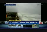
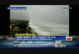
two words describe hurricane sandy, huge and dangerous. the national hurricane center saying that sandy is picking up speed as it bears down on the eastern seaboard's largest cities. this is a massive storm expected to trigger life-threatening storm surges. let me repeat that, life-threatening storm surges. as well as powerful winds and snow in the appalachians. and a life-and-death situation has been unfolding off of north carolina's outer banks as well. the coast guard says that 16 people who were on board this ship, "the hms bounty," all abandoned ship after it began taking on water and lost its propulsion in heavy seas. we have breaking news to tell you right now.
8:46 am

that ship has now sunk. luckily those people were able to abandon ship. 14 of them were rescued before the ship went down. but two people are still missing. and joining us on the telephone now, u.s. coast guard vice admiral robert parker. what's the latest you know about the effort to find those two missing people? >> thank you, ashleigh. the latest we heard, we've debriefed the 14 people we did get back to elizabeth city, north carolina. they are in good health. all the people abandoned ship earlier this morning, as they were abandoning ship, three people were washed overboard. they were all wearing emergency suits. only one of those people made to it the life raft. the two people not found did not make it into the life rafts. the helicopters out there that did the hoists returned because of fuel state. we've had a continuous coverage on scene with a coast guard
8:47 am
c-130 aircraft and another mh-60 helicopter. but no further sightings of those two people. >> can you explain what emergent suits and how that might play into their survivability? >> they're made to protect the person wearing it to keep them both afloat, hopefully face-up and also to provide them thermal protection from the water. but many these conditions, it's very problematic to maintain your position in seas out there in excess of 20 feet, the winds are probably down to about 45 knots but that's still pretty extraordinary conditions for a person in the water. these are suits designed to both hold on to the heat that's so important when you're immirsers in the water and also to keep you afloat. >> one person made it to the life rafts, the other two didn't. are you going to be able to have helicopters or any rescue equipment out there to keep looking for these other two
8:48 am

people? >> we're out there right now. we have a helicopter and a c-130 out there. we've recalled the coast guard cutter elements. she's on her way there now. if she can make decent speed, she'll be there before dark this evening. we've recalled also the coast guard cutter gal tin, one of our older 378-foot cutters out of charleston, south carolina. they should be on scene by tomorrow morning. >> they can be out there safely, admiral -- i can't believe that ship was out there in the first place in weather like this. but those rescue crews can be out there safely at this point? >> yes, ma'am. that's one of the reasons that our ships tend to cost a little more is they have to be out there in some pretty nasty weather. they're built to a little higher standard. we have people that are pretty experienced in this weather. we try to avoid it when we can. but obviously as we hope for the best, we plan for the worst. >> and i just have to ask you, with this kind of a storm, this is just unimaginable.
8:49 am
what are the odds that your guys are going to be able to find these two people out there? >> that's a good question. but we have everything we can going for us except for the weather right now. we've had assets on scene. we do have what we call a self-locating data market buoy, a small buoy that drifts about the same rate as a person in the water would. that gives us a continuous gps feed for which direction the drift is going. and having continuous coverage gives us absolutely the best hope. finding a person in the water in those conditions is really, really difficult, especially when the visibility is as low as it is right now. >> godspeed to you and all of your crews who are doing this heroic work. i hope you are lucky in this mission. and i'll check this with you later to find out how it's going. vice admiral robert parker, thank you very much. >> thank you. >> we have more right after the break. but i still have a runny . [ male announcer ] dayquil doesn't treat that. huh? [ male announcer ] alka-seltzer plus rushes relief to all your worst cold symptoms, plus it relieves your runny nose.
8:50 am

[ sighs ] thank you! [ male announcer ] you're welcome. that's the cold truth! as part of a heart healthy diet. that's true. ...but you still have to go to the gym. ♪ the one and only, cheerios flavor boost, meet beef. it's swanson flavor boost. concentrated broth to add delicious flavor to your skillet dish in just one stir. mmm! [ female announcer ] cook, meet compliments. get recipes at flavorboost.com.

8:52 am

hurricane sandy is getting stronger, now packing sustained winds of 0 miles an hour, and the gusts are going up to 115 miles per hour. this huge dangerous storm is expected to make landfall tonight or very early tomorrow morning, and when it does, maryland, by all means, could get slammed. right now the eye of the storm is a couple hundred miles to the southeast of the state. our sandra endo joins us live now from ocean city, maryland. sandra, i have been watching the progression of your live shots
8:53 am

all the way through last night and into this morning, and at times it seems that it's passed you, and then we come back to you 20, 30 minutes later, and are you holding on for dear life. what is exactly happening now? >> ashleigh, the word i am using for this storm so far and it hasn't even reached landfall yet is relentless because it has just been nonstop raining, but really significant as of the last hour is the wind, and as you mentioned, it's intensifying out there, and we're feeling it out here, and really the gusts have picked up here, and we have watched this beach erode right in front of our eyes. we've seen high tide throughout the morning and then massive waves crashing on these protective sands they have here. i'm actually on the street side, the property side of the sand dunes, and we've watched the waves come on over, crash into these sand dunes and actually flood this area and so that's a
8:54 am

big concern for local residents and authorities here is the flooding, and the storm surge by these massive waves. the storm surge and the tidal surge is something they're going to look for. take a look at the waterfront property here, ashleigh. you could also see how the water has accumulated. there's flooding here already. this is something they were preparing for, and a lot of the residents here have boarded up their homes and they're certainly bracing for the worst, but keep in mind, as you have been forecast, the worst is yet to come. high tide is happening later this evening, and that's when the heart of hurricane sandy is expected to come through this area. ashleigh. >> high tide -- where you are, maryland, as well as several states all along the eastern seaboard. what has that done in terms of telling the people where you are to get to better shelter, to get
8:55 am

to higher and safer ground. have they. >> they've taken all the warnings seriously, and there was a mandatory evacuation order in place, and the deadline was last night for residents in downtown ocean city, to get out of town. all nonresidents, as well, had to leave ocean city. route 50 into this area is shut down, and those residents who have decided to hunker down and ride out the storm, they are being urged to stay inside because clearly you could see the conditions are just worsening by the hour, so it's -- >> i don't mean to play inside baseball here, about the i think a lot of our viewers are going to be looking at you holding on for dear life and wondering when you are going seek shelter and how you are going to stay state of. >> yeah. i'm actually just being very cautious out here, obviously, because you never know what mother nature does, but we're staying protected. we're trying to really seek
8:56 am

shelter in the building that we're broadcasting from, so from time to time, you know, we are protected, obviously, so we try to stay safe out here as well. >> all right, sandy. be careful out there, and we will come to you for updates. the last hurricane to disrupt maryland was hurricane irene, a little over a year ago, and that caused widespread flooding and huge power outages, and this word just in as well. the u.s. supreme court will not be convening tomorrow because of hurricane sandy perhaps not surprising. thank you, everyone, for watching. stay tuned to cnn as we continue to update you throughout the day on the powerful impact of hurricane sandy. try as much as you like, anyway you like. like new teriyaki grilled shrimp. offer ends soon!

8:58 am

if you're a man with low testosterone, you should know that axiron is here. the only underarm treatment for low t. that's right, the one you apply to the underarm. axiron is not for use in women or anyone younger than 18. axiron can transfer to others through direct contact. women, especially those who are or who may become pregnant, and children should avoid contact where axiron is applied as unexpected signs of puberty in children or changes in body hair or increased acne in women may occur.
8:59 am

report these signs and symptoms to your doctor if they occur. tell your doctor about all medical conditions and medications. do not use if you have prostate or breast cancer. serious side effects could include increased risk of prostate cancer; worsening prostate symptoms; decreased sperm count; ankle, feet, or body swelling; enlarged or painful breasts; problems breathing while sleeping; and blood clots in the legs. common side effects include skin redness or irritation where applied, increased red blood cell count, headache, diarrhea, vomiting, and increase in psa. see your doctor, and for a 30-day free trial, go to axiron.com. can help make you a better investor. our e-trade 360 investing dashboard shows you where your money is, live. e-trade pro is so usable you'll actually use it. and our apps are the ultimate in mobile investing. become a better investor at e-trade.
257 Views
1 Favorite
IN COLLECTIONS
CNN (San Francisco) Television Archive
  Television Archive News Search Service
  The Chin Grimes TV News Archive
Uploaded by TV Archive on
